Humphreys with 3 mile
Item
-
Title
-
Humphreys with 3 mile
-
Description
-
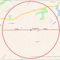
It's estimated that the maximum distance students would have walked to this school is 3 miles one way. The graphic shows the area from which students may have walked to this school.
-
Tag
-
Transportation, Bus, Routes
-
Transportation, Routes, Walk
-
Place
-
Virginia
-
Identifier
-
1043963
-
Is Version Of
-
1043963_RCH_Humphreys_with_3_mile.png
-
Is Part Of
-
Research
-
Date Created
-
2024-01-21
-
Format
-
png
-
Number
-
546dc44317f792071c6835315f4aca29e83128d3d04a9ede8a4e51c8e868f5dd
-
Source
-
/Users/Julie/Downloads/drive-download-20240223T232504Z-001/Humphreys with 3 mile.png
-
Publisher
-
Digitized by Edwin Washingon Project
-
Rights
-
Edwin Washington Society
-
Language
-
English
-
extracted text
-
/)
goun St
Appalachian ROUND HILL g \Lou
Trail Corridor
Stoneleigh
Course
z
S
\k@
<
BLUEMONT
601
W Raspé
’ H hrev' N
3 Miles UMpNreys . _ 3 Miles ’ 3
------------------ ----%o -G, e G G G G G G G -G G o
@
<® paxson Rd
] AIRMONT
N
S
Q;Q-b F/
'@\b County of Loudoun, VGINgEST, HERE, Garmin, SafeGraph, GeoTechnoIogies,JI, ¢, METI/NASA, USGS, EPA,
$ NPS, USDA
�