Limestone W with 3 mile
Item
-
Title
-
Limestone W with 3 mile
-
Description
-
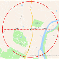
It's estimated that the maximum distance students would have walked to this school is 3 miles one way. The graphic shows the area from which students may have walked to this school.
-
Tag
-
Transportation, Bus, Routes
-
Transportation, Routes, Walk
-
Place
-
Virginia
-
Identifier
-
1043968
-
Is Version Of
-
1043968_RCH_LimestoneW_with_3_mile.png
-
Is Part Of
-
Research
-
Date Created
-
2024-01-21
-
Format
-
png
-
Number
-
b1d74f1fcf87256827565e4612ce6db105db1e396139952ab4c608bc26f62a45
-
Source
-
/Users/Julie/Downloads/drive-download-20240223T232504Z-001/LimestoneW with 3 mile.png
-
Publisher
-
Digitized by Edwin Washingon Project
-
Rights
-
Edwin Washington Society
-
Language
-
English
-
extracted text
-
4o
J’a/[’y
STUMPTOWN
White's
gional Park.
'sland
%
% Temple Hall
(sl Farm )
o
,a
X
o
Mason
Island
Limestone W 3 Miles
MA
lr’%luamfi
m
3
@
»
o
=
o
o
e —_—
X
Club aQ
Of
Virginia at
Beacon
Hill Morven Park ~
in, SafeGraph, GeoTechnologies, Inc, METI/NASA, USGS, EPA,
NPS, USDA
�