-
Title
-
Pleasant Valley with 3 mile
-
Description
-
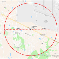
It's estimated that the maximum distance students would have walked to this school is 3 miles one way. The graphic shows the area from which students may have walked to this school.
-
Tag
-
Transportation, Bus, Routes
-
Transportation, Routes, Walk
-
Place
-
Virginia
-
Identifier
-
1044008
-
Is Version Of
-
1044008_RCH_PleasantValley_with_3_mile.png
-
Is Part Of
-
Research
-
Date Created
-
2024-01-21
-
Format
-
png
-
Number
-
c2800f40b06bed70bf9190e68b366c3ebf23c124692398486a4d4d9007eaf7b8
-
Source
-
/Users/Julie/Downloads/drive-download-20240223T232504Z-001/PleasantValley with 3 mile.png
-
Publisher
-
Digitized by Edwin Washingon Project
-
Rights
-
Edwin Washington Society
-
Language
-
English
-
extracted text
-
0\\59 e
ARCOLA
Wp_ Bravo Rd
Gr,,nete‘ RA
659
Delta Rd
s Echo Rd
N
o\ =
&
<
o 1]
¢
o9 g
Dulles
International
Airport
Willarg Ry
§ \ Pleasant
_ %n 4, Valley 3 Miles e
&)
SOUTH
RIDI+\I~G‘
Pp#sant Wiy,
Valley I Ry
7 Golf CHANTILI
e vy of Nillia rfax County, VA, VGIN, Esri, HERE, Garmin, SafeGraph,
chnologies, Inc, METI/NAGQ,SA, USGS, EPA, NPS, USDA
Q
—
e~
�