Robey School with 3 mile
Item
-
Title
-
Robey School with 3 mile
-
Description
-
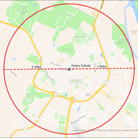
It's estimated that the maximum distance students would have walked to this school is 3 miles one way. The graphic shows the area from which students may have walked to this school.
-
Tag
-
Transportation, Bus, Routes
-
Transportation, Routes, Walk
-
Place
-
Virginia
-
Identifier
-
1044014
-
Is Version Of
-
1044014_RCH_RobeySchool_with_3_mile.png
-
Is Part Of
-
Research
-
Date Created
-
2024-01-21
-
Format
-
png
-
Number
-
ae6c46126311f3f44aaaef98f7b68e134e8bbcd8a37d7b0b5296a2b2f8e2b535
-
Source
-
/Users/Julie/Downloads/drive-download-20240223T232504Z-001/RobeySchool with 3 mile.png
-
Publisher
-
Digitized by Edwin Washingon Project
-
Rights
-
Edwin Washington Society
-
Language
-
English
-
extracted text
-
PAEONIA
SPRINGS
U7 8109
A\ Rd
6\“
o
WOODBURN
N\
Club
Of
Virginia at {
Beacon
e / Morven Park
N
Harrison
Island
Tuscarora HS
Balls BlufN
Battlefield
Regional Park\
lda Lee Park
S
v
.(l
A
Qrk 5 .
3 Miles N Robey School £ 3 Miles
\L@‘ %,
Z
o
Washington &
Old Dominion
Trail
SE
o
<
O .
7\
patt®"
/.
™~
N
\ \
County of Loudoun, \(GIN®Esri, HERE, Garmin, SafeGraph, GeoTechnologies, Inc, ME‘I"Ifi\lA USGS, EPA
B\
PS, USDA
�