Rock Hill with 3 mile
Item
-
Title
-
Rock Hill with 3 mile
-
Description
-
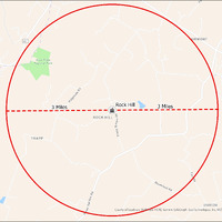
It's estimated that the maximum distance students would have walked to this school is 3 miles one way. The graphic shows the area from which students may have walked to this school.
-
Tag
-
Transportation, Bus, Routes
-
Transportation, Routes, Walk
-
Place
-
Virginia
-
Identifier
-
1044015
-
Is Version Of
-
1044015_RCH_RockHill_with_3_mile.png
-
Is Part Of
-
Research
-
Date Created
-
2024-01-21
-
Format
-
png
-
Number
-
a46f3528df057147c78551f0bb92e8a6c7a5b823a6d6bb017511f308ed609ed5
-
Source
-
/Users/Julie/Downloads/drive-download-20240223T232504Z-001/RockHill with 3 mile.png
-
Publisher
-
Digitized by Edwin Washingon Project
-
Rights
-
Edwin Washington Society
-
Language
-
English
-
extracted text
-
N
Blue Ridge
Regional Park
&
@
L
<
D
&
3 Miles
TRAPP
o
&
<
o
o
~
@
O
<
@
2
QIRMONT
Rock Hill 3 Miles
Bl mm————— e —————-—-
0
ROCK HILL %
=
o
O
%
.
=
o
o
£099Y Bottom
nd
Q0
<,
%o
/77;‘}@/
UNISON
County of Loudoun, VGIIN®ESri, HERE, Garmin, SafeGraph, GeoTechnologies, Inc, METI/NASA, USGS, EPA,
NPS, USDA
�