Mount Gilead with 3 mile
Item
-
Title
-
Mount Gilead with 3 mile
-
Description
-
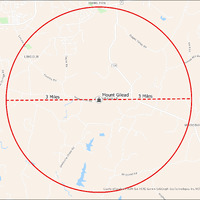
It's estimated that the maximum distance students would have walked to this school is 3 miles one way. The graphic shows the area from which students may have walked to this school.
-
Tag
-
Transportation, Routes, Walk
-
Place
-
Virginia
-
Identifier
-
1043986
-
Is Version Of
-
1043986_RCH_MountGilead_with_3_mile.png
-
Is Part Of
-
Research
-
Date Created
-
2024-01-21
-
Format
-
png
-
Number
-
3018a550bcb696420f42bb7301ec70339ba4874bc43991778f97ad5411212f2e
-
Source
-
/Users/Julie/Downloads/drive-download-20240223T232504Z-001/MountGilead with 3 mile.png
-
Publisher
-
Digitized by Edwin Washingon Project
-
Rights
-
Edwin Washington Society
-
Language
-
English
-
extracted text
-
\o W S
Spr;
Dr/ngs Rd
x’égc
Te,
%
OO
>
o>
LINCOLN
py JojAel
O,
“n,
o, Ry
__gwm
HAMILTON
O,
09@@
@//@y@d %;D
N\‘\\\ Rd
x\O“@?
704
Mount Gilead -
WPODBURN
Mt Gilead RY
County of Loudew®VGIN, Esri, HERE, Garmin, SafeGraph, GeoTechnologies, Inc, METI/NAS
s
SGS, EPA,
NPS, USDA
WG
�