Mount Olive Baptist with 3 mile
Item
-
Title
-
Mount Olive Baptist with 3 mile
-
Description
-
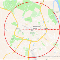
It's estimated that the maximum distance students would have walked to this school is 3 miles one way. The graphic shows the area from which students may have walked to this school.
-
Tag
-
Transportation, Routes, Walk
-
Place
-
Virginia
-
Identifier
-
1043987
-
Is Version Of
-
1043987_RCH_MountOliveBaptist_with_3_mile.png
-
Is Part Of
-
Research
-
Date Created
-
2024-01-21
-
Format
-
png
-
Number
-
a75976f05d93bb884b17a6d87791cdf996fb62eb0f9796d5568372da1661dd6e
-
Source
-
/Users/Julie/Downloads/drive-download-20240223T232504Z-001/MountOliveBaptist with 3 mile.png
-
Publisher
-
Digitized by Edwin Washingon Project
-
Rights
-
Edwin Washington Society
-
Language
-
English
-
extracted text
-
D
Club
Of
Virginia at i '
Beacon
Hill
Morven Park
Harrison
Island
Tuscarora HS
Balls Bluff:
\'
Regional Park
Lee Park
v
® rk, . o
= st Mount Olives
B wn
A Ra S : LEESBURG Baptist g
’bro@ 2 @ -----rn-- -a-"»b e G G G G -G T
(\\06\ Ko
Washington &
Old-Dominion a
Trail ~
> 2/
Westpark
a O
)/
E
o 3
WOODBURN O
we'
9.
Cour\\t ) of Loudoun, @ Esri, HERE, Garmin, SafeGraph, GeoTechnologies, Inc, METI/NA
- e\\‘°
�