Mountain Shadow with 3 mile
Item
-
Title
-
Mountain Shadow with 3 mile
-
Description
-
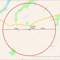
It's estimated that the maximum distance students would have walked to this school is 3 miles one way. The graphic shows the area from which students may have walked to this school.
-
Tag
-
Transportation, Routes, Walk
-
Place
-
Virginia
-
Identifier
-
1043992
-
Is Version Of
-
1043992_RCH_MountainShadow_with_3_mile.png
-
Is Part Of
-
Research
-
Date Created
-
2024-01-21
-
Format
-
png
-
Number
-
c4f4783faa34486ae59c119d614c20858b094657cc9bf50b2060eaf7f1070a73
-
Source
-
/Users/Julie/Downloads/drive-download-20240223T232504Z-001/MountainShadow with 3 mile.png
-
Publisher
-
Digitized by Edwin Washingon Project
-
Rights
-
Edwin Washington Society
-
Language
-
English
-
extracted text
-
Virginia
> \
National
Golf Club oalachi . ROUND Hi
Stoneleigh
Golf
Course
- g
Mountain &
/
/ ’
/
AIRMONT
Regional P
— v
County of Loudoun, VGIN, Esri, HERE, Garmin, SafeGraph, GeoTechnologies, Inc, bhETI/NASA, USGS, EPA,
. NPS, USDA
-
Virginia
> \
National
Golf Club oalachi . ROUND Hi
Stoneleigh
Golf
Course
- g
Mountain &
/
/ ’
/
AIRMONT
Regional P
— v
County of Loudoun, VGIN, Esri, HERE, Garmin, SafeGraph, GeoTechnologies, Inc, bhETI/NASA, USGS, EPA,
. NPS, USDA
�