Oak Grove 2 with 3 mile
Item
-
Title
-
Oak Grove 2 with 3 mile
-
Description
-
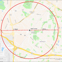
It's estimated that the maximum distance students would have walked to this school is 3 miles one way. The graphic shows the area from which students may have walked to this school.
-
Tag
-
Transportation, Routes, Walk
-
Place
-
Virginia
-
Identifier
-
1044000
-
Is Version Of
-
1044000_RCH_OakGrove2_with_3_mile.png
-
Is Part Of
-
Research
-
Date Created
-
2024-01-21
-
Format
-
png
-
Number
-
1df01c132b01d452123164a60f0b8f5058e46bc3e54c1e7151390ac8fb701f42
-
Source
-
/Users/Julie/Downloads/drive-download-20240223T232504Z-001/OakGrove2 with 3 mile.png
-
Publisher
-
Digitized by Edwin Washingon Project
-
Rights
-
Edwin Washington Society
-
Language
-
English
-
extracted text
-
E 602
o .
5 Community
o? Center/
Heritage Farm
1757
Museum
Sugarland RY
Stream Valle
Oak Grove
1q 1oidoiny
v
' rrybrook RQ
red e
e \ Y meyeT Loudoun, Fairfax County, VA, MNCPPC, VGIN, Esri, HERE, Garmin, SafeGraph, GeoTechnol
g Inc, METI/NASA, USGS, EPA, NPS,
Delta Rd ‘ |
-
E 602
o .
5 Community
o? Center/
Heritage Farm
1757
Museum
Sugarland RY
Stream Valle
Oak Grove
1q 1oidoiny
v
' rrybrook RQ
red e
e \ Y meyeT Loudoun, Fairfax County, VA, MNCPPC, VGIN, Esri, HERE, Garmin, SafeGraph, GeoTechnol
g Inc, METI/NASA, USGS, EPA, NPS,
Delta Rd ‘ |
�