Round Hill 1912 Temp Secondary with 3 mile
Item
-
Title
-
Round Hill 1912 Temp Secondary with 3 mile
-
Description
-
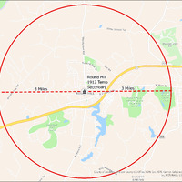
It's estimated that the maximum distance students would have walked to this school is 3 miles one way. The graphic shows the area from which students may have walked to this school.
-
Tag
-
Transportation, Routes, Walk
-
Place
-
Virginia
-
Identifier
-
1044018
-
Is Version Of
-
1044018_RCH_RoundHill1912TempSecondary_with_3_mile.png
-
Is Part Of
-
Research
-
Date Created
-
2024-01-21
-
Format
-
png
-
Number
-
7328e064023c23e7f3d8e6e3743fbf257f12e7a1c847dcc9ef326cd8fabfb90b
-
Source
-
/Users/Julie/Downloads/drive-download-20240223T232504Z-001/RoundHill1912TempSecondary with 3 mile.png
-
Publisher
-
Digitized by Edwin Washingon Project
-
Rights
-
Edwin Washington Society
-
Language
-
English
-
extracted text
-
o
7
Appalachian
Trail Allder school Rq
=
o
8‘ Mountain View
S ES
<
o
X
o
Evenip
& < S s
» /‘O @// A
;&‘ X sy .J
x
c -
g Round Hill
/ . 11912 Temp
& —~ .
& 3 M|I es Secondary PURCELLVILLE
== R?HlLf' o £
. Golf and
Golf al
Country
1S \.\"XQZ S
97
Spr/nas rA
ngefferson County GIS Office, VGIN, Esri, HERE, Garmin, SafeGraph, GeoTechnoIogle@
Inc, METI/NASA, USGS, EPA, NPS, UEDA
SILCOTT ne METY
S SPRING
�