Round Hill 1 School 9 with 3 mile
Item
-
Title
-
Round Hill 1 School 9 with 3 mile
-
Description
-
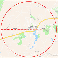
It's estimated that the maximum distance students would have walked to this school is 3 miles one way. The graphic shows the area from which students may have walked to this school.
-
Tag
-
Transportation, Routes, Walk
-
Place
-
Virginia
-
Identifier
-
1044019
-
Is Version Of
-
1044019_RCH_RoundHill1School9_with_3_mile.png
-
Is Part Of
-
Research
-
Date Created
-
2024-01-21
-
Format
-
png
-
Number
-
8b06a238af553df7095336093bba1a3c1907e00cb6c4a406e217f142357b27cb
-
Source
-
/Users/Julie/Downloads/drive-download-20240223T232504Z-001/RoundHill1School9 with 3 mile.png
-
Publisher
-
Digitized by Edwin Washingon Project
-
Rights
-
Edwin Washington Society
-
Language
-
English
-
extracted text
-
o
¥
Allder School Rq
Mountain View
ES
Py oAN0IBPOOM
o2 ROlRoqu|1fl Hill 1 PURCELL
< s g | ol /
& i (School #9)
e Raspb
S,
O
o
SILCOTT
ounty GIS Office &/GINI EsH, HERE, Garmin, SafeGraph, GeoTechnologies,
Rd Inc, METI/NASA, USGS, EPA, NPS, USDA
Paxson
County of Loudoun, JeffersemC
-
o
¥
Allder School Rq
Mountain View
ES
Py oAN0IBPOOM
o2 ROlRoqu|1fl Hill 1 PURCELL
< s g | ol /
& i (School #9)
e Raspb
S,
O
o
SILCOTT
ounty GIS Office &/GINI EsH, HERE, Garmin, SafeGraph, GeoTechnologies,
Rd Inc, METI/NASA, USGS, EPA, NPS, USDA
Paxson
County of Loudoun, JeffersemC
�