Primary documents related to transportation
5.8 Colored Field Trips
12-2 Bus Drivers
12-3 Routes
12-4 Bus Inventories
12-5 Shelter
12-6 Garage and Maintenance
12-7 Accidents and Safety
12-8 General and Cost Figures
12-9 New Buses
Primary documents related to transportation
5.8 Colored Field Trips
12-2 Bus Drivers
12-3 Routes
12-4 Bus Inventories
12-5 Shelter
12-6 Garage and Maintenance
12-7 Accidents and Safety
12-8 General and Cost Figures
12-9 New Buses
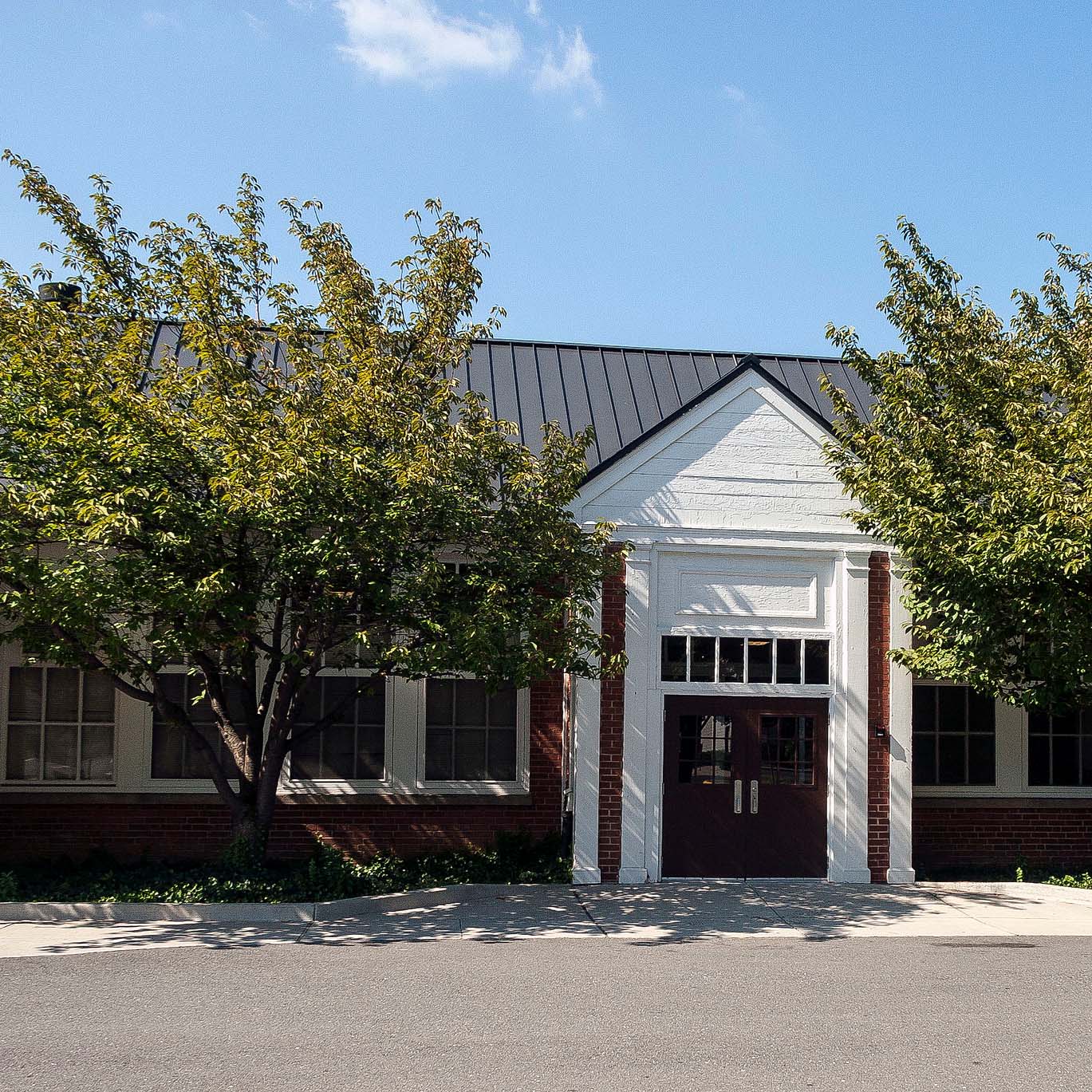
It's estimated that the maximum distance students would have walked to this school is 3 miles one way. The graphic shows the area from which students may have walked to this school.
March 16, 1940 page 3 of a letter from the law firm of Houston, Houston & Hastie to Superintendent OL Emerick. In face of the inequities in school bus transportation between Black and White students, this page discusses "the obligation of the county to furnish Negro school children bus transportation on equal terms with white children similarly circumstanced."
January 17, 1941 correspondence between F.F. Jenkins Director Administration and Finance of the Virginia State Board of Education and Mr. C.T. Dean of Clifton, Virginia. The correspondence references Mr. Dean's request for a school or school bus for children in his community and advises Mr. Dean to seek the help of his local school board for such matters.
October 10, 1955 School Board Meeting Agenda includes school bus route changes, comparison of one, three and five year insurance plans, school construction and additions
September 8, 1952 correspondence to O.L. Emerick and School Board to extend Bus 20's route (O.L. Jacobs school bus driver). Submitted by parents: George Fields, Thomas White, Frances Longesbram, Charles White, C. Pearson and Robert Stone - page 1
September 8, 1952 correspondence to O.L. Emerick and School Board to extend Bus 20's route (O.L. Jacobs school bus driver). Submitted by parents: George Fields, Thomas White, Frances Longesbram, Charles White, C. Pearson and Robert Stone - page 2
March 20, 1945 County-Wide League of Loudoun letter to Superintendent Emerick and School Board endorses Janie Redmond recommendations made on March 6, 1945. These included Teacher Grade load decrease through school consolidation, providing necessary transportation, building repairs, school supply requests, infrastructure upgrades, additional teachers and maintenance custodians
Estimated date = 1930s. The petition requests school bus transportation for colored students to the 'Loudoun County Training Center' it's assumed to be Pre-Douglass High School (1941). Students are from Willisville, St Louis, Middleburg Colored, Bull Run (Aldie) and Gleedsville (Mountain Gap Colored). Additional petition signees to those in 'EWP 02-5 A Yr Unknown Petition for school bus transportation for colored students to the Loudoun County Training Center', otherwise it appears to be the same petition.
Date unknown, but it is very likely the letter from parents that is referenced in the May 10, 1954 School Board Meeting Agenda requesting School Bus Driver Leroy Allen be reappointed for the coming school year. (See also EWP 2-2 May 10, 1954 School Board Meeting Agenda and Minutes)
Date unknown, but because the petition requests school bus transportation for colored students to the 'Loudoun County Training Center' it's assumed to be Pre-Douglass High School (1941). Students are from Willisville, St Louis, Middleburg Colored, Bull Run (Aldie) and Gleedsville (Mountain Gap Colored).
September 11, 1934 petition from patrons of Lovettsville school to adjust newly established school bus route so that it extends to the road from Lovettsville to Wheatland.
May 8, 1948 and May 22, 1948 correction petition from Susan M. Cromer to Loudoun County Board of Supervisors. Petition request school bus transportation for Aldie children living on route 632. Petition contains parents names and ages of children to be transported.
March 17, 1930 petition from the mother of a child attending the Paxson school to keep the school open (if only for half a day) vs. bussing children to another school.
March 17, 1930 letter from Mrs. Walter Parks to Superintendent OL Emerick joining in on the petition to keep Paxson school open instead of closing it and having elementary school students ride on the bus with Round Hill High School students.
August 1936 request from patrons of closed Mt Gilead School (illegible) for school bus transportation and August 13, 1936 response from school board refusing the request.
August 6, 1936, request for school bus service for Mt. Gilead. Written by Mrs. Gilbert Jewell to Mr. Emerick. August 13, 1936, response from Superintendent O.L. Emerick refusing the request.
August 11, 1945 request for school bus route change by the White Round Hill Elementary patrons (formerly Sunny Ridge Elementary). Also April 14, 2016 description of the Sunny Ridge School after its purchase by Mrs. Meta Watts Smith several years before 1949.
December 5, 1950 petition from patrons of Mt. Gilead to Loudoun County School Board requesting an extension of the school bus route to the junction of route 662 and route 728 and thence along route 728 to the Joseph Y Bailey farm (approx 2.5 miles from the original end of the school bus route).
Yr Unk, petition for school bus service to Aldie school for children living north of Little River Turnpike (Rte 50) and VA Department of Historic Resources Information Sheet for Gilberts Corner Gas Station.
Dec 14, 1944 correspondence from Superintendent O.L. Emerick to attorney James Raby. The letter authorized an additional teacher for the Middleburg Colored School. School Board supports building a new (colored?) school near St Louis & Middleburg. The School Board could not act on a request for public school transportation but did offer to financially compensate parents who arranged private transportation. Letter states that Loudoun County School Board is interested in improving the education conditions of its colored children.
Nov. 16, 1944 Correspondence from Attorney James Raby responding to Superintendent O.L. Emerick's correspondence of Oct 20, 1944. Raby cites the need for school transportation for children that need it.
Dec 14, 1944 correspondence from Superintendent O.L. Emerick to attorney James Raby. Emerick addresses new colored teacher for Middleburg, new school in the St Louis area and additional transportation for colored students.
Records include: 1947 - 1949 announcements regarding opportunity for Junior and Senior high school students to tour historic Williamsburg, Yorktown and Jamestown sites as well as attend the historic re-enactment play "Common Glory"; permission slips and school bus schedules for attendees signed by LCPS Superintendent O.L. Emerick; list of attendees - date unknown; announcements from State Superintendent of Public Instruction G. Tyler Miller.
May 4, 1953 correspondence from Superintendent O.L. Emerick requesting timely submittal of bills from Long's Service Station; May 4, 1953 Correspondence from Clerk Ruth Emerick requesting receipted bill from F.A. Crosen; May 6, 1953 correspondence from Transportation Supervisor G.R. Hughes to VA. State Police with enclosed inspection tickets; Letter from Mrs. Popovich (date unknown) accompanying check for repair costs related to son's Rock Throwing Incident.
April 13, 1953 correspondence from Principal Sydnor to Superintendent O.L. Emerick requesting school bus for May 13, 1953 Douglass High School French Club trip to Washington, D.C. and May 16, 1953 Student Patrol trip to baseball game.
April 17, 1953 correspondence from Superintendent Emerick to Principal Sydnor approving school bus for May 13, 1953 Douglass High School French Club trip to Washington D.C. and denying school bus for May 16, 1953 trip to baseball game. Superintendent Emerick cites reasons for denial.
April 23, 1953 correspondences from Principal Talbot to Superintendent O.L. Emerick requesting 3rd school bus for June 2 or 3, 1953 Carver D.C. Zoo Trip and Superintendent Emerick's presence at Carver's 8th Grade Closing Ceremony on June 3, 1953. April 24, 1953 correspondence from Superintendent O.L. Emerick responding to those requests: No on the 3rd school bus; Yes on attending 8th grade Closing Ceremony
April 27, 1953 correspondence from teacher Marion Bowman to Superintendent O.L. Emerick requesting school bus transportation of Bull Run School students to Douglass Elementary May Day exercises on May 14, 1953.
April 30, 1953 correspondence from Carver teachers Furr, Washington, Ewing and Jones to Superintencdent O.L. Emerick requesting school bus transportation for a tour of Washington D.C. Proposed dates for trip were May 12 or 13, 1953.
July 22, 1948 correspondence from Superintendent O.L. Emerick of corrected school bus schedule for trip to Williamsburg ("Common Glory" Play). Schedule shows two buses, one starting at Tolbert's home the other starting at Bluemont. Both buses then travel to Douglass High making intermediate stops. Both buses leave Douglass High School (presumably for Williamsburg) at the same time.
June 4, 1953 correspondence from Clerk Ellwood B. Jones to Superintendent O.L. Emerick. Correspondence accompanied payment for mileage use of two school buses that provided transportation of Carver students to Washington D.C. zoo on June 3, 1953. See also March 24, 1953 correspondence from Carver teachers Daniel, Barrett and Johnson.
March 24, 1953 correspondence from Carver elementary school teachers Daniel, Barrett and Johnson to Superintendent O. L. Emerick requesting school bus transportation for trip to zoo. Proposed dates for trip were June 2 or 3, 1953. Mileage and driver costs were to be covered by attendees.
March 26, 1953 correspondence from Principal H. G. Ellis to Superintencent O.L. Emerick requesting school bus transportation for May 22, 1953 trip to Mount Vernon.
May 2, 1953 correspondence between Superintendent O.L. Emerick and Mrs. Marion Bowman re: using school bus to transport students to and from Douglass Elementary on May 14, 1953 for extra-curricular activities. Emerick outlines the cost and time constraints to use a school bus. Extra-curricular activities could have been a May Day celebration.
May 14, 1953 correspondence from O. L. Emerick to Miss Nanie Coles notifying her of the end of year Nokes school closing and that children would be transported by school bus to a school near Herndon.
May 14, 1953 correspondence from O. L. Emerick to Mr. W. T. Woodson notifying him of the end of year closing of two, Loudoun colored schools near border between Fairfax and Loudoun and of tuition changes made to transfer students to Fairfax school near Herndon. Assumed the schools were Nokes and Conklin colored schools.
1940 correspondence from Superintendent O.L. Emerick to various individuals re: School bus shelters. Correspondence from K.D. Lindsay re: school bus shelters. Correspondence from C.R. Mullen/H.J. Neale re: School bus shelters Correspondence from R.V. Long re: School Bus Shelter blueprints.
Correspondences from Superintendent O.L. Emerick: October 27, 1944 letter to motorists to obey state laws on passing school buses loading or unloading students; September 17, 1946 letter to Loudoun Times Mirror paper expressing gratitude for article promoting motorist driving safely in the interest of children; October 25, 1947 memo requesting publication of an unknown attachment; November 14, 1947 letter to the Blue Ridge Herald paper promising 'School Zone' signs would be posted for Bluemont school.
October 7, 1952 correspondence from Superintendent O.L. Emerick to Mr. Alfred K. Talbot Jr. The correspondence requests Mr. Talbot submit school bus schedules for bus #33 & #34 (Carver Elementary) (presumably for the 1952/53 school year).
November 12, 1952 correspondence from Superintendent O.L. Emerick to bus driver O. Ray Stewart (Bus #34). The correspondence directs Mr.Stewart to change the route of school bus # 34 which served Carver Elementary (presumed effective for the remainder of the 1952/53 school year).
Ocober 7, 1952 request from Superintendent O.L. Emerick to Mr. Robert A. Myers (Aldie Principal?) of Aldie VA. The request is for schedule information for buses 5 and 23 which deliverd students to Aldie Elementary in 1952-1953. Information re: 8th grade students in Middleburg was part of request.
October 7. 1952 correspondence from Superintendent O.L. Emerick to bus driver Lee Roy Allen (Bus #35). The correspondence requests Mr. Allen submit his school bus schedule (presumably for the 1952/53 school year). School bus # 35 served Conklin Elementary.
October 15, 1952 correspondence from Superintendent O.L. Emerick to bus driver Lee Roy Allen (Bus #35). School bus # 35 served Conklin Elementary. The correspondence requests Mr. Allen make corrections to the school bus schedule he submitted (presumably for the 1952/53 school year). See also 'EWP 03 Yr 1952 Emerick request to Lee Roy Allen for school bus schedule'.
October 27. 1952 correspondence from Superintendent O.L. Emerick to bus driver Lee Roy Allen (Bus #35). School bus # 35 served Conklin Elementary. The correspondence requests Mr. Allen make a 2nd set of corrections to the school bus schedule he submitted (presumably for the 1952/53 school year). See also 'EWP 03 Yr 1952 Emerick request to Lee Roy Allen for school bus schedule corrections (1st corrections)'.
October 10, 1952 correspondence from Superintendent O.L. Emerick to Mrs J.H. Forsyth. The correspondence is a response from Emerick to her earlier request for a change in Bus # 26's route.
1952 School Bus Routes All Races (Aldie to Middleburg to Douglass Elementary and High Schools. Purcellville to Hillsboro, to Round Hill, to Carver to Douglass Elementary and High Schools) (Bus # 26 and Bus # 30)
1952 School Bus Routes All Races (Coleman's to Sterling to Leesburg, Ryan to Ashburn to Leesburg and Cool Spring and Mountain Gap to Leesburg) (Bus # 18, Bus # 28 and Bus # 29)
1952 School Bus Routes All Races (Paeonian Springs to Waterford and Clark's Gap to Leesburg, ? To Leesburg and Ryan to Ashburn to Leesburg) (Bus # 38, Bus # ? and Bus # 29)
1952 School Bus Routes All Races (Red Hill to Sycoline to Leesburg, Milltown to Waterford and Clark's Gap to Leesburg and Furnace Mountain to Lucketts to Leesburg) (Bus # 14, Bus # 15 and Bus # 17)
Letter from Mrs. Popovich (date unknown) accompanying check for repair costs related to son's Rock Trhowing Incident. May 29, 1953 correspondence from Superintendent O.L. Emerick acknowledging receipt of check for repair costs.
January 28, 1953 correspondence from Superintendent O.L. Emerick to bus driver Lee Roy Allen (Bus #35). The correspondence directs Mr. Allen to change the route of school bus # 35 (presumed effective for the remainder of the 1952/53 school year). School bus # 35 served Conklin Elementary.
May 4. 1953 correspondence from Superintendent O.L. Emerick to Mrs. Ernestine T. Stewart. The correspondence notifies her of Conklin Elementary School closure at school year end. Transportation to a Herndon school will be provided beginning next school year.
May 22, 1953, letter from Superintendent OL Emerick to Mr. F. Luke VanSickler of Purcellville. Moving Bluemont's 7th grade to Round Hill elementary in 1954 because number of Bluemont teachers will drop from 3 to 2. Emerick request Mr. VanSickler do a study of school bus #25 to help determine which students attending Round Hill ride pass Bluemont.
May 29, 1953 correspondence from Superintendent O.L. Emerick to Hackney Brothers. Purpose: let Hackney Brothers know LCPS has purchased their bus bodies from Wayne Works. Likely in response to a proposal for bus bodies from Hackney Brothers.
Letter from Mrs. Popovich (date unknown) to a Mr. Hughes acknowledging that her son threw the rock that broke a window on Bus # 35 and offering to pay for the repair. May 25, 1953 correspondence from Superintendent O.L. Emerick responding to Popovich's offer with the repair cost.
April 27, 1953 correspondence from Superintendent O.L. Emerick soliciting bids for school bus bodies from McDonald and Jenkins, S.J. Meeks' Son, Hackney Brothers, Colonial Motor Sales, Purcellville Motor Company, Windsor Motor Company and Bishop's Service Station. Responding correspondences from Hackney Brothers to O.L. Emerick. (See also EWP 12-4 Yr 1953 Letter from Emerick to Hackney re: New Bus Bids)
January 21, 1930 Illustrated School Bus Transportation map example and request from Supervisor Division Research and Surveys C.E. Myers to School Superintendent O.L. Emerick. Map includes miles between points on the map, types of schools and student related data.
September 21, 1953, request from September 18, 1953, Hillsboro school PTA meeting to change school bus # 9's route. Request from Grace F. Baber to Mr. Emerick.
April 17, 1953 Invoice and payment for field trip from Lucketts to Mt Vernon; April 24, 1953 Invoice and payment for field trip from Lucketts to Washington DC Zoo; May 26, 1953 Invoice and payment for field trip from Lucketts to Washington DC TV Show. Trips taken in buses 38 and 43.
April and May 1953 invoices and payments for 4/16/1953 school bus trip from Ashburn to Leesburg in support of symphony orchestra. Invoice and payment for 5/15/2953 trips from Ashburn and Leesburg to Washington DC. Also, a thank you letter dated June 8, 1953 from Ashburn and Mountain Gap schools for Emerick's permission to take a June 2, 1953 trip to Richmond, Colonial Williamsburg, Jamestown and Yorktown.
April and May 1953 invoices and payments for school bus trips in support of high school baseball, football and basketball games, and a trip to The Smithsonian and the Capital.
May 14, 1956 School Board Agenda including : purchase of school bus chassis, school bus bodies, list of resignations and appointments, allocation of school interior painting funds, band instruction requests and how funded, estimates for school house improvements, recommended school bus driver and maintenance staff assignments, recommended school janitor assignments, recommended school secretary assignments, 1956-1957 teacher vacancies.
It's estimated that the maximum distance students would have walked to this school is 3 miles one way. The graphic shows the area from which students may have walked to this school.
It's estimated that the maximum distance students would have walked to this school is 3 miles one way. The graphic shows the area from which students may have walked to this school.
It's estimated that the maximum distance students would have walked to this school is 3 miles one way. The graphic shows the area from which students may have walked to this school.
It's estimated that the maximum distance students would have walked to this school is 3 miles one way. The graphic shows the area from which students may have walked to this school.
It's estimated that the maximum distance students would have walked to this school is 3 miles one way. The graphic shows the area from which students may have walked to this school.
It's estimated that the maximum distance students would have walked to this school is 3 miles one way. The graphic shows the area from which students may have walked to this school.
It's estimated that the maximum distance students would have walked to this school is 3 miles one way. The graphic shows the area from which students may have walked to this school.
It's estimated that the maximum distance students would have walked to this school is 3 miles one way. The graphic shows the area from which students may have walked to this school.
It's estimated that the maximum distance students would have walked to this school is 3 miles one way. The graphic shows the area from which students may have walked to this school.
It's estimated that the maximum distance students would have walked to this school is 3 miles one way. The graphic shows the area from which students may have walked to this school.
It's estimated that the maximum distance students would have walked to this school is 3 miles one way. The graphic shows the area from which students may have walked to this school.
It's estimated that the maximum distance students would have walked to this school is 3 miles one way. The graphic shows the area from which students may have walked to this school.
It's estimated that the maximum distance students would have walked to this school is 3 miles one way. The graphic shows the area from which students may have walked to this school.
It's estimated that the maximum distance students would have walked to this school is 3 miles one way. The graphic shows the area from which students may have walked to this school.
It's estimated that the maximum distance students would have walked to this school is 3 miles one way. The graphic shows the area from which students may have walked to this school.
It's estimated that the maximum distance students would have walked to this school is 3 miles one way. The graphic shows the area from which students may have walked to this school.
It's estimated that the maximum distance students would have walked to this school is 3 miles one way. The graphic shows the area from which students may have walked to this school.
It's estimated that the maximum distance students would have walked to this school is 3 miles one way. The graphic shows the area from which students may have walked to this school.
It's estimated that the maximum distance students would have walked to this school is 3 miles one way. The graphic shows the area from which students may have walked to this school.
It's estimated that the maximum distance students would have walked to this school is 3 miles one way. The graphic shows the area from which students may have walked to this school.
It's estimated that the maximum distance students would have walked to this school is 3 miles one way. The graphic shows the area from which students may have walked to this school.
It's estimated that the maximum distance students would have walked to this school is 3 miles one way. The graphic shows the area from which students may have walked to this school.
It's estimated that the maximum distance students would have walked to this school is 3 miles one way. The graphic shows the area from which students may have walked to this school.
It's estimated that the maximum distance students would have walked to this school is 3 miles one way. The graphic shows the area from which students may have walked to this school.
It's estimated that the maximum distance students would have walked to this school is 3 miles one way. The graphic shows the area from which students may have walked to this school.
It's estimated that the maximum distance students would have walked to this school is 3 miles one way. The graphic shows the area from which students may have walked to this school.
It's estimated that the maximum distance students would have walked to this school is 3 miles one way. The graphic shows the area from which students may have walked to this school.
It's estimated that the maximum distance students would have walked to this school is 3 miles one way. The graphic shows the area from which students may have walked to this school.
It's estimated that the maximum distance students would have walked to this school is 3 miles one way. The graphic shows the area from which students may have walked to this school.
It's estimated that the maximum distance students would have walked to this school is 3 miles one way. The graphic shows the area from which students may have walked to this school.
It's estimated that the maximum distance students would have walked to this school is 3 miles one way. The graphic shows the area from which students may have walked to this school.
It's estimated that the maximum distance students would have walked to this school is 3 miles one way. The graphic shows the area from which students may have walked to this school.
It's estimated that the maximum distance students would have walked to this school is 3 miles one way. The graphic shows the area from which students may have walked to this school.
It's estimated that the maximum distance students would have walked to this school is 3 miles one way. The graphic shows the area from which students may have walked to this school.
It's estimated that the maximum distance students would have walked to this school is 3 miles one way. The graphic shows the area from which students may have walked to this school.
It's estimated that the maximum distance students would have walked to this school is 3 miles one way. The graphic shows the area from which students may have walked to this school.
It's estimated that the maximum distance students would have walked to this school is 3 miles one way. The graphic shows the area from which students may have walked to this school.
It's estimated that the maximum distance students would have walked to this school is 3 miles one way. The graphic shows the area from which students may have walked to this school.
It's estimated that the maximum distance students would have walked to this school is 3 miles one way. The graphic shows the area from which students may have walked to this school.
It's estimated that the maximum distance students would have walked to this school is 3 miles one way. The graphic shows the area from which students may have walked to this school.
It's estimated that the maximum distance students would have walked to this school is 3 miles one way. The graphic shows the area from which students may have walked to this school.
It's estimated that the maximum distance students would have walked to this school is 3 miles one way. The graphic shows the area from which students may have walked to this school.
It's estimated that the maximum distance students would have walked to this school is 3 miles one way. The graphic shows the area from which students may have walked to this school.
It's estimated that the maximum distance students would have walked to this school is 3 miles one way. The graphic shows the area from which students may have walked to this school.
It's estimated that the maximum distance students would have walked to this school is 3 miles one way. The graphic shows the area from which students may have walked to this school.
It's estimated that the maximum distance students would have walked to this school is 3 miles one way. The graphic shows the area from which students may have walked to this school.
It's estimated that the maximum distance students would have walked to this school is 3 miles one way. The graphic shows the area from which students may have walked to this school.
It's estimated that the maximum distance students would have walked to this school is 3 miles one way. The graphic shows the area from which students may have walked to this school.
It's estimated that the maximum distance students would have walked to this school is 3 miles one way. The graphic shows the area from which students may have walked to this school.
It's estimated that the maximum distance students would have walked to this school is 3 miles one way. The graphic shows the area from which students may have walked to this school.
It's estimated that the maximum distance students would have walked to this school is 3 miles one way. The graphic shows the area from which students may have walked to this school.
It's estimated that the maximum distance students would have walked to this school is 3 miles one way. The graphic shows the area from which students may have walked to this school.
It's estimated that the maximum distance students would have walked to this school is 3 miles one way. The graphic shows the area from which students may have walked to this school.
It's estimated that the maximum distance students would have walked to this school is 3 miles one way. The graphic shows the area from which students may have walked to this school.
It's estimated that the maximum distance students would have walked to this school is 3 miles one way. The graphic shows the area from which students may have walked to this school.
It's estimated that the maximum distance students would have walked to this school is 3 miles one way. The graphic shows the area from which students may have walked to this school.
It's estimated that the maximum distance students would have walked to this school is 3 miles one way. The graphic shows the area from which students may have walked to this school.
It's estimated that the maximum distance students would have walked to this school is 3 miles one way. The graphic shows the area from which students may have walked to this school.
It's estimated that the maximum distance students would have walked to this school is 3 miles one way. The graphic shows the area from which students may have walked to this school.
It's estimated that the maximum distance students would have walked to this school is 3 miles one way. The graphic shows the area from which students may have walked to this school.
It's estimated that the maximum distance students would have walked to this school is 3 miles one way. The graphic shows the area from which students may have walked to this school.
It's estimated that the maximum distance students would have walked to this school is 3 miles one way. The graphic shows the area from which students may have walked to this school.
It's estimated that the maximum distance students would have walked to this school is 3 miles one way. The graphic shows the area from which students may have walked to this school.
It's estimated that the maximum distance students would have walked to this school is 3 miles one way. The graphic shows the area from which students may have walked to this school.
It's estimated that the maximum distance students would have walked to this school is 3 miles one way. The graphic shows the area from which students may have walked to this school.
It's estimated that the maximum distance students would have walked to this school is 3 miles one way. The graphic shows the area from which students may have walked to this school.
It's estimated that the maximum distance students would have walked to this school is 3 miles one way. The graphic shows the area from which students may have walked to this school.
It's estimated that the maximum distance students would have walked to this school is 3 miles one way. The graphic shows the area from which students may have walked to this school.
It's estimated that the maximum distance students would have walked to this school is 3 miles one way. The graphic shows the area from which students may have walked to this school.
It's estimated that the maximum distance students would have walked to this school is 3 miles one way. The graphic shows the area from which students may have walked to this school.
It's estimated that the maximum distance students would have walked to this school is 3 miles one way. The graphic shows the area from which students may have walked to this school.
It's estimated that the maximum distance students would have walked to this school is 3 miles one way. The graphic shows the area from which students may have walked to this school.
It's estimated that the maximum distance students would have walked to this school is 3 miles one way. The graphic shows the area from which students may have walked to this school.
It's estimated that the maximum distance students would have walked to this school is 3 miles one way. The graphic shows the area from which students may have walked to this school.
It's estimated that the maximum distance students would have walked to this school is 3 miles one way. The graphic shows the area from which students may have walked to this school.
It's estimated that the maximum distance students would have walked to this school is 3 miles one way. The graphic shows the area from which students may have walked to this school.
It's estimated that the maximum distance students would have walked to this school is 3 miles one way. The graphic shows the area from which students may have walked to this school.
It's estimated that the maximum distance students would have walked to this school is 3 miles one way. The graphic shows the area from which students may have walked to this school.
It's estimated that the maximum distance students would have walked to this school is 3 miles one way. The graphic shows the area from which students may have walked to this school.
It's estimated that the maximum distance students would have walked to this school is 3 miles one way. The graphic shows the area from which students may have walked to this school.
It's estimated that the maximum distance students would have walked to this school is 3 miles one way. The graphic shows the area from which students may have walked to this school.
It's estimated that the maximum distance students would have walked to this school is 3 miles one way. The graphic shows the area from which students may have walked to this school.
It's estimated that the maximum distance students would have walked to this school is 3 miles one way. The graphic shows the area from which students may have walked to this school.
It's estimated that the maximum distance students would have walked to this school is 3 miles one way. The graphic shows the area from which students may have walked to this school.
It's estimated that the maximum distance students would have walked to this school is 3 miles one way. The graphic shows the area from which students may have walked to this school.
It's estimated that the maximum distance students would have walked to this school is 3 miles one way. The graphic shows the area from which students may have walked to this school.
It's estimated that the maximum distance students would have walked to this school is 3 miles one way. The graphic shows the area from which students may have walked to this school.
It's estimated that the maximum distance students would have walked to this school is 3 miles one way. The graphic shows the area from which students may have walked to this school.
It's estimated that the maximum distance students would have walked to this school is 3 miles one way. The graphic shows the area from which students may have walked to this school.
It's estimated that the maximum distance students would have walked to this school is 3 miles one way. The graphic shows the area from which students may have walked to this school.
It's estimated that the maximum distance students would have walked to this school is 3 miles one way. The graphic shows the area from which students may have walked to this school.
It's estimated that the maximum distance students would have walked to this school is 3 miles one way. The graphic shows the area from which students may have walked to this school.
It's estimated that the maximum distance students would have walked to this school is 3 miles one way. The graphic shows the area from which students may have walked to this school.
It's estimated that the maximum distance students would have walked to this school is 3 miles one way. The graphic shows the area from which students may have walked to this school.
It's estimated that the maximum distance students would have walked to this school is 3 miles one way. The graphic shows the area from which students may have walked to this school.
It's estimated that the maximum distance students would have walked to this school is 3 miles one way. The graphic shows the area from which students may have walked to this school.
It's estimated that the maximum distance students would have walked to this school is 3 miles one way. The graphic shows the area from which students may have walked to this school.
It's estimated that the maximum distance students would have walked to this school is 3 miles one way. The graphic shows the area from which students may have walked to this school.
It's estimated that the maximum distance students would have walked to this school is 3 miles one way. The graphic shows the area from which students may have walked to this school.
It's estimated that the maximum distance students would have walked to this school is 3 miles one way. The graphic shows the area from which students may have walked to this school.
It's estimated that the maximum distance students would have walked to this school is 3 miles one way. The graphic shows the area from which students may have walked to this school.
It's estimated that the maximum distance students would have walked to this school is 3 miles one way. The graphic shows the area from which students may have walked to this school.
It's estimated that the maximum distance students would have walked to this school is 3 miles one way. The graphic shows the area from which students may have walked to this school.
It's estimated that the maximum distance students would have walked to this school is 3 miles one way. The graphic shows the area from which students may have walked to this school.
It's estimated that the maximum distance students would have walked to this school is 3 miles one way. The graphic shows the area from which students may have walked to this school.
It's estimated that the maximum distance students would have walked to this school is 3 miles one way. The graphic shows the area from which students may have walked to this school.
It's estimated that the maximum distance students would have walked to this school is 3 miles one way. The graphic shows the area from which students may have walked to this school.
It's estimated that the maximum distance students would have walked to this school is 3 miles one way. The graphic shows the area from which students may have walked to this school.